I’ve always ridden, logged rides, and trained with a multi-sport watch (except when I was a kid and had one of those gaugey sort of things), and in the last few years I have also used the top display on my Garmin Virb Elite (my review here but no longer manufactured) as a simple bike computer.
I love to train and try to improve, but I also want to also just have an enjoyable bit of fitness without worrying overly much about what I’m doing so I’ve resisted getting a dedicated bike computer, for that reason.
Many others by other manufacturers seemed like good candidates – GPS/bike computers by Wahoo, Bryton, Lezyne, and so on. All make some nice bike computers/GPS units, and some very nearly fit the bill. Though one of the common drawbacks was routing or re-routing – many of which required a cellphone to be connected all the time for that feature. I wanted maps right on the machine, not continually using battery power and needing to be connected to my phone. I just liked the idea of always having maps right on there no matter what, and sometimes when mountain biking it can be iffy on cell signals.
I would have liked WiFi upload too – which when finishing a ride would automatically upload to the home network when nearby. But this seems to be uncommon, only on something like the high-end Edge 1030. Bluetooth upload is fine as a second choice for me.
On a side note – why didn’t Garmin make Garmin Express for computers have the ability to use the computer’s Bluetooth (if available) to upload in addition to the tethered USB method? Anyway…
So I did a lot of research, a lot comparisons, read a lot of advice from others who bike a lot, and read lots of messages on forums from users who actually use – and sometimes have issues with – each model (check out one of my favorite bike forums – Twospoke.com).I had a number of bike computers in mind, but really the deciding factor for me turned out to not be price (okay, yes; of course), or manufacturer, or even features (many were fairly comparable in that aspect), etc – but the hands-down uniquely great fact that Garmin Edge’s have the ability to be customized with Garmin Connect IQ. Connect IQ allows you to bring smart-like apps, widgets, and data fields to the bike computer – for expanded features, customization, and more abilities than the base unit may have. Garmin devices are amazingly customizable in the first place, a huge plus of course, but Connect IQ was the deciding factor for me. Just having bought a new Vivoactive 3 Music I quickly could see how powerful the Connect IQ ecosystem was.
So I really wanted to stick with Garmin for this reason specifically – in addition to features and familiarity with the brand. Eventually, I came to decide on the Garmin Edge 520, but a week before I ordered that model I changed my mind and went with the Garmin Edge 520 Plus.
The differences between the two? Well, basically the Plus has routable maps where the regular 520 does not (obviously the Plus has more memory than the regular 520 and probably some slightly different, newer hardware). It also has a few small things like Trendline Popularity Routing, more about this later.
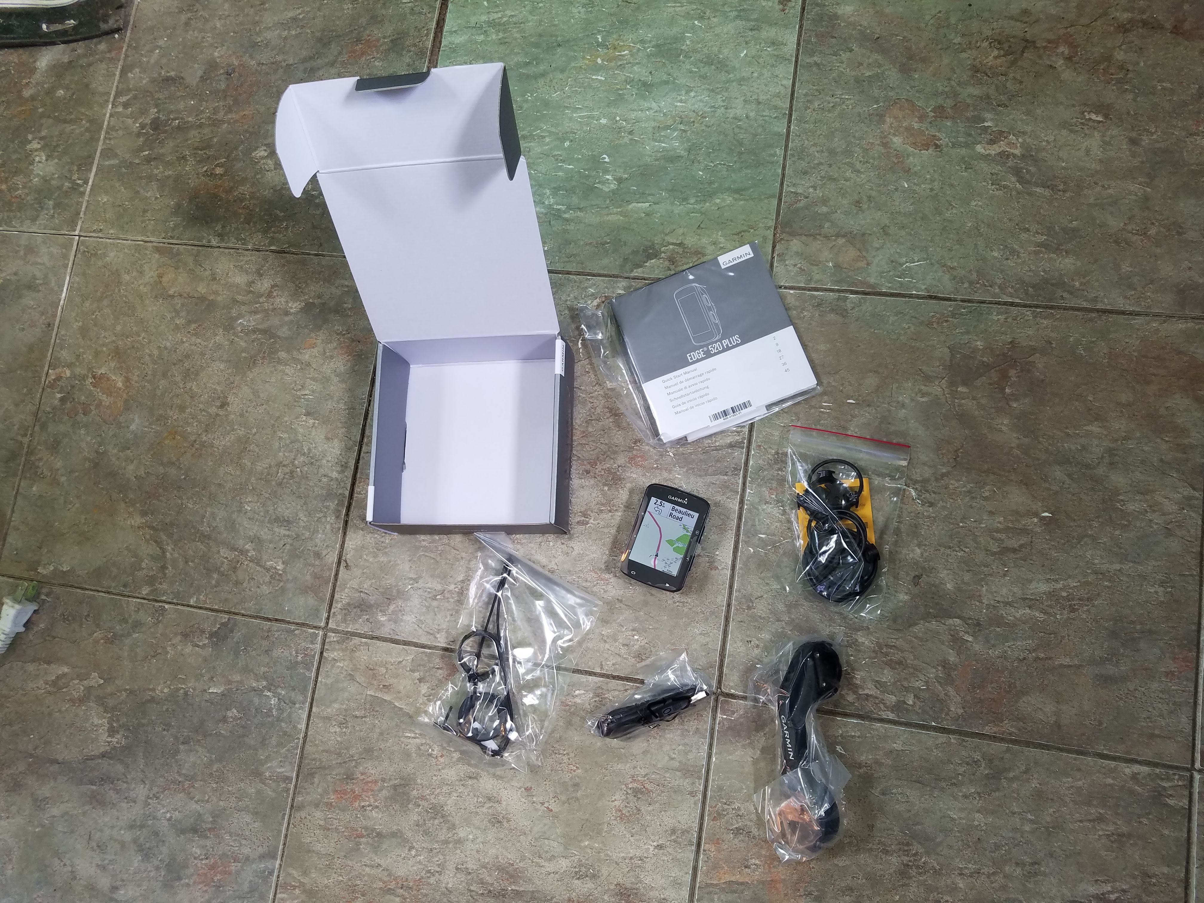
As with everything that I have bought from Garmin all included items are packed nicely into the box, wrapped in plastic baggies and padded well. What I seemed to have not included in this photo is the cardboard insert that holds the Edge securely in the box. Needless to say everything is secured and safe for shipping.
The box is easy to open as are the sealed plastic baggies. Included are the Edge (the face protected like most of Garmin’s stuff by a plastic fake map screen protector), a quick reference manual and other miscellaneous pamphlets, the charger cable, the out-front bike mount, and a variety of spacers for the mount and Allen wrenches for tightening it, two stem mounts and lots of bands for the stem mount in many sizes, and a Garmin lanyard.
The Edge feels solid and beefy. No, not heavy (for you weight weenies out there) – it’s only 2.2 ounces (62.5 grams). It’s not heavy, but looking at it you can almost expect it to be lighter than it is; is packed with electronics, memory, a heavy-duty battery, and various electronics and physical switches. The Wahoo Elemnt for example is about 93 to 104 grams (depending on who you talk to).
The Edge 520 Plus came out in mid-2018, while it’s older originator the 520 had previously been released in mid-2015.
The size is about 1.9 by 2.9 inches, with a thickness of about .8 of an inch (49.0 x 73.0 x 21.0 mm) with the display being 1.4 x 1.9 (35.0 x 47.0 mm) which gives you a 2.3-inch diagonal screen with a resolution of 200 x 265 pixels. It’s not going to be as high-resolution as your big HD-screened cellphone but it is more than capable of doing the job needed for displaying colored graphics and maps, gauges and stats. You’ll find some GPS bike computers like the Wahoo Elemnt have a higher resolution (the Elemnt is black and white though), but I doubt you’ll have any problems reading the maps just fine on the 520. It does have sound, it will make various buzzes and such. Not real loud and this was one of my concerns – but even with high winds, a skull-cap that covers my ears, and traffic I could still hear the beeps.
The battery is a standard modern lithium-ion with Garmin claiming up to 15 hours of battery life (these stats are always under perfect conditions of course). I believe a more common estimate is around ten hours or so, depending on whether you have the backlight on, Bluetooth enabled, or not, etc.
It has an IPX7 rating which makes it water-resistant to one meter of depth, but more importantly, makes it resistant to splashing and rain and snow, and if you drop it in a puddle it’s probably going to be just fine, likely. Leaving it underwater for a long period of time – not so much.
You’ll find the shape is fairly aerodynamic, it’s a rounded rectangle like most any bike GPS, with all four top sides sloping inward underneath with the forward end sloping inward at a deeper angle. It seems thick compared to, say, cellphones but width/length-wise it is very small. The screen occupies the majority of the top, ending a short distance from the edges on all sides.
For me the unit’s size is almost perfect – of course, this is going to be a matter of personal preference but for me, it is small enough to be unobtrusive when I am riding but easily readable when I need to see it – either on the out-front mounts or on the stem mount. For those with eyesight problems you might want to make sure you don’t use the whole ten fields per screen and bump it down to something that you can see better – you can go all the way down to one data field per screen; if you can’t see that then you probably shouldn’t be biking without assistance, I would guess. And there are some nice highly visible Connect IQ Data Fields out there.
On the upper left side is the power/brightness button with two up/down selection buttons below it, on the upper right is the menu/select option button and below it is the return/back button, at the bottom edge is the lap button on the left and on the right the button to start/stop the timer. Buttons are good-sized and easily pressed.
Coming from a touchscreen world the buttons may take a little getting used to. And yes – I touched the screen a few times when I first got it; forgetting that does not work.
Touchscreens are great, but as you probably know sometimes when there is moisture on them they may not function correctly, don’t work at all, or even tend to flakily press the wrong thing on the screen in a random manner when you try to use them. Do I miss a touchscreen interface? Somewhat, but it doesn’t take much to get used to the buttons after a bit. It is a bit of a negative unless of course it’s raining hard and you need to press a button.
On the bottom side is the quarter-turn Garmin mounting bracket, more about this in the next section.
Also on the bottom and near the bottom rear edge is a rubbery flapper that keeps the standard mini-USB plug waterproof. I’ve heard of people having problems with the little flapper coming off but Garmin should help you get a replacement if needed, and it is attached with a small screw under the edge of it, so it is user-replaceable. My advice is just to go easy on it and not tug it needlessly when you are opening it to charge. There is no SD card storage. I don’t have the exact amount of storage but the onboard storage has full maps of every road in whatever area you are buying the Edge from – all roads, both major and minor are included, everything.
Below this is the lanyard hole. The included lanyard is nice, and installing it is easy – and gives you a little security when you are carrying it, plus you can loop it around your stem or mount or something if you are concerned about safety (and maybe even security if you turn your back on your bike for a moment). More about this later.
Also onboard is a barometric altimeter so it is not relying on the GPS to calculate altitude changes, you can also calibrate this using the GPS though it is normally self-calibrated at the beginning of your ride after a good GPS lock. The GPS connects to US GPS’s as well as GLONASS and Galileo. There is an option for which GPS series you want to connect to – the more it connects to the more accurate it is, but there is a slight increase in battery usage when more GPS sat locks are used. There is a thermometer which seems to work quite well, unlike the one on my Vivoactive 3 Music (can’t really expect it to be that correct – it’s on my wrist!) and a GPS compass.
The Myriad Abilities of the Edge 520 Plus
I’ll go a little into set-up below but in addition to hardware specs I wanted to go over some of the Edge 520 Plus’s software abilities and settings.
If you are used to call notifications on your smartwatch and/or like to really keep up on what’s going on, the 520 has Bluetooth Smart Text & Call Notifications. These are selectable in a few different categories – text, social networking, and others; so you can pick which or if you receive notifications. You can further change some of these in Garmin Connect on your mobile device itself.
For fitness stats, there are Recovery Adviser metrics, VO2 Max Estimation, FTP tracking and testing, Personal Records, Cycling Dynamics metrics, TP Levels, (you really need a power meter for some of these), Time in Zones, and personal records (some of which are downloaded from Garmin so it can be shown across multiple connected/supported Garmin devices). You can also download and use the workouts/training calendar from Garmin Connect and use HIIT training. Between the 520 itself, the Garmin Connect App, the Garmin Connect website, and tons of Connect IQ apps; even the most fitness data-hungry users will find plenty to peruse and help in their training.
You can also race against a previously completed activity using the virtual partner – which you can turn off if not needed, or toggle on whenever you do.
The 520 can also control things like the Garmin Virb series (remotely taking photos, videos, etc) as well as Garmin Varia bike lights, and it integrates with the Garmin Varia bike radar system and will connect to an ANT+ FE-C Trainer – of course with regular bike sensors you can use it indoors with a regular ‘dumb’ trainer too.
For safety, there is Integrated Live Tracking with a connected phone and even Group Tracking (though certain conditions have to be meant for this to work). And Incident Detection which sends an emergency contact notification to selected contacts. You are given thirty seconds to cancel the notification in case of a false alarm.
Courses from multiple services can be sent to the Garmin app or imported, and in some cases sent directly to the Edge via an app. Courses from (of course) Garmin Connect, Strava, Komoot, TrailForks, and a number of others can be transferred to it in various ways – with methods ranging from easy to a bit more involved. More about all of this later.
The number of sensors that can be added is quite large – pretty much anything ANT+ including cadence, speed, power (including full settings), speed/cadence, and the Garmin Virb (added just like a sensor, same screen), and Varia lights and radar, Even weight scales. The nice thing about the sensors and connected devices is that you can rename them so you can have more than “65562 Connected” when a sensor connects. Nice feature there.
Unfortunately, there is a sort of ‘sensor pool’ where you connect a sensor and it can be used by any biking activity type – for most people this won’t matter. But it is conceivable that if you have a road bike and mountain bike sitting in your garage and you accidentally jiggle the mountain bike while you are getting your road bike ready it MIGHT pick up one of the MTB’s sensors that were activated with movement, giving the first sensor of whatever type it is a priority.
At this point you can go into the sensor connection screen in Settings and manually connect the proper sensor, making it take precedence over the wrong one. This of course would have to be in the same category as the incorrect one.
Another nice feature is something called Extended Display which displays some of the Edge’s metrics on compatible watches in addition to the onboard display.
You can also share some info with other users of Edge models. There are multiple types of things you can share, probably the most useful being courses. Another useful option is group track of others who are using the various models of the Edge.
And if you do keep your phone connected you can get voice queues for training and directions. Having a phone connected means you get things like updated weather (with the built-in weather app or Connect IQ ones).
Post-ride it will show you recovery time and a detailed summary of your ride and some other options. Usually, it will quickly upload your ride to Garmin if your phone is connected and nearby but you can manually sync it in Garmin Connect if needed. Some people have reported some issues with their’s getting unsynced to their phone/Garmin Connect and indeed I had this happen just one time so far while doing an indoor ride. Annoying but a simple re-sync was all that was needed, as well as powering down the device – and it only happened once (possibly because of something I did when changing settings for this review). You can also sync data via plugging the Edge into your computer with Garmin Express installed.
There is even the option of being able to do screenshots onboard.
Frankly, there are so many things you can do with the Edge 520 Plus, as well as options and ways to customize it; not to mention so many apps, widgets, and data fields on Connect IQ that you can add – I’m not going to even attempt to go over everything in detail. Connect IQ is one of the major pluses with the Edge series, I think. No other bike computer or bike GPS manufacturer seems to have anything like it.
For specific help on each function check out Garmin’s pretty good Edge 520 Plus help page -it’s a no-nonsense searchable resource that you are probably going to want to keep the URL handy for as you learn to use the Edge.
Mounting
You’ll find all sorts of Garmin and third-party mounts that this will fit on. Garmin’s mount system is secure, well-established, and common for Garmin bike comp/GPS’s. Just make sure you get a good full turn into the mount and that the pad is fitted in correctly, not usually a problem.
Installing the out-front mount is easy, there are multiple spacers included so it should fit anything from large handlebars to smaller diameter ones. The spacers have ridges that fit nicely into the accompanying slots in the clamp of the out-front mount, holding them in place securely. Included Allen wrenches are used to tighten the clamp. The out-front mount also has an under-side attachment point for other devices also. This mount works great if you want the Edge in a fairly easy position to see, obviously out-front and in between your handlebars.
You can mount things like the Virb, other action cameras, and even a Garmin Battery Power Pack in the underside mounting position. BTW, you can charge it with a Garmin battery pack or any battery pack while the Edge is running.
For the stem mounts, they are pretty easy to install also. There are two included and lots of bands of a few different sizes. You use two bands with each end of the bands fitting into the tabs that are sticking out, with the bands wrapping around the bottom of your stem (more instructions from Garmin).
I like the stem mounts and the included out-front, but I did get a third-party out-front mount that also allows the Virb to be slung underneath, see the photo at the end of this section and that I liked.
The 520 Plus also comes with a lanyard, which fits through a mounting slot on the underside near the back edge.
Attaching the Edge is as simple as slotting it onto the mount at a right angle and twisting it straight, and it’s snapped into place. It is very secure, as secure as two plastic pieces fit together can be I suppose. I’ve heard stories of it popping off if it is not mounted correctly or in the advent of an extreme accident.
If you want more security, or just a handy way to carry it from your bike to the house there is the included lanyard. For extra security, you could also hook this lanyard around your stem or the handlebars or maybe the out-front mount itself, or something like that.
60-pound test leader line used as lanyard (shown on 520 with silicone case installed).
For my use I’ve attached a 60-pound test leader line made of stainless steel coated with nylon – some sets of these have nice little clasps attached – I use this as a safety lanyard instead of the included one. The clasps won’t fit through the lanyard’s hole on the Edge but if you get a longer line you can make a gentle u-shape in the line in the middle, and slide it through the lanyard hole starting at the u-shape (see pic). Then pass the rest of the two ends through the U and you have a nice and very strong cable that you can slip around whatever part of the bike you need it to, and it is much less obtrusive than the lanyard. I use this method with my Garmin Virb Elite Action Camera and the various mounts, including an aero-bar mount.
This could also provide a little extra security when it comes to turning your back on your bike for a few minutes. A thief could easily do a quick twist of the Edge and be gone, but fumbling with the clasp or trying to cut it with a knife is much harder and a bit more time-consuming (and this line is pretty hard to cut with a knife). And hopefully, you wouldn’t be leaving your bike with the Edge on it unattended for long anyway. The lanyard would serve the same purpose if looped around something before the Edge is put on the mount.
The non-Garmin out-front mount also, just like the included one, allows me to sling the Virb underneath. See the second pic below. This was a bit more trouble to attach to the handlebars but was worth it, as it is real metal and attaches right in the middle unlike the Garmin one. No issue with the Garmin one, I just kinda like things symmetrical 😉
Set up is very similar to Garmin’s other fitness/exercise-related devices. Turn it on with the upper-left button (power) and start entering your weight, height, etc using a combination of the up and down buttons on the left and the menu/select button (upper-right button) to go to the next option. Of note here – you can only configure it for one person when it comes to body stats.
You can continue with the setup by adding sensors. You may have gotten the mountain biking bundle or something like that where the sensors may already be synced, or you may need to attach the sensors to your bike, or you may already have bike sensors – whatever way you are going to do it you can either add them here or wait and add them later.
Activity Profiles – the presets are Train, Indoor, and Race. There are various preset options already configured for you, for example the Indoor profile already has the internal GPS turned off. You can either change, create new, rename, or delete them here and modify any of the many options available for each. I left the Indoor as-is and renamed Train to Road and Race to MTB and went on to modify each according to my preferences. You can just skip by this part for now if you don’t want to mess with any changes because – of course – you can modify ANY of these settings later.
Syncing your phone is one of the important first settings to get accomplished. For this you’ll need to have your phone handy, Bluetooth turned on, Garmin Connect app installed and ready to add a device. I’m not going to go into the specifics here as it is similar to connecting other Garmin devices and not so dissimilar from syncing other devices.
A friend had a question about using it without a smartphone. You can use many of the features without a phone connected and you should be able to set it up and use it even without one. Of course you would need to plug it into a computer to upload rides, update the maps and firmware, etc.
The options on this device are many, and you may want to refer to the official Garmin Manual as well as the Garmin Forums for the Edge 520 Plus in addition to your own experimenting with how you want things configured.
Once you have things initially set up you can go in and tweak individual options – as I said above; there are a large varied number of them.
For example – for each “Activity Profile” i.e. ride type you can have up to five pages, with up to ten data fields in each page plus you can toggle on and off things like the Cycling Dynamics, Virtual Partner, Lap Summary, Elevation, Compass, Map pages right before a ride (or in a ride).
You can also create new Activity Profiles, rename and modify existing ones, change the color of each Activity Profile, toggle GPS/Glonass/Galileo satellite acquisition on and off, adjust map settings, alerts, Auto Features, etc.
You can have multiple Connect IQ data fields per screen, with a total of ten per “Activity Profile” or ride type. In real-world use you do have to remember that some Connect IQ data fields are doing a lot of calculations, so – depending on the Connect IQ field – you may find that some running in the background really affects the computer’s performance, especially when using map routing.
One slight disappointment for me, likely not for others; is there doesn’t seem to be any way to pair the Edge to more than one mobile device. With other Garmin devices, I have been able to do this – sometimes with a bit of futzing around and sometimes not. But with the Edge 520 Plus there seems to be only the ability to pair it to one device running Garmin Connect and that’s it. Of course, you can have multiple separate Garmin devices paired in Garmin Connect itself for each mobile device, but the Edge itself seems to be only pairable to just one mobile device running Garmin connect at a time. You can connect it to multiple computers running Garmin Express.
Probably not any issue for others, and just a minor annoyance to me – one that I frankly don’t even notice now.
On a bit of a side note here – Garmin’s Basecamp does work with the 520 Plus, though you can’t use it to install maps or anything like that (maps are automatically updated via Garmin Express/Garmin Connect). But you can use it to download, edit, and upload POI’s and tracks (courses).
In the way of ‘hacking’ (not really), you can also add a start-up message in case you think your Edge might get lost or something. Plug it in, use your computer’s file manager to navigate to the Edge, click the GARMIN folder and edit the startup.txt file using Notepad or something similar. Type your message under the line it mentions in the comment line in the file, and you can also edit the <display = 0> for the time delay.
Using the Garmin Edge 520 Plus
The power-up sequence for the 520 Plus is fairly quick (unless you have added a delay using the above text file change), once it boots you’ll see icons denoting your previously-added sensors along the top, as well as one for battery power, GPS, Bluetooth (connection to your phone), temperature, and time. Anything flashing means that the sensor is not connected as yet, if you have a cadence or speed sensor for example – move your bike or pedals a bit to bring it out of power-down.
If you have multiple sensors for various bikes previously connected then some of these icons are going to keep flashing of course, if you are not using that particular sensor/bike.
A note here, BTW; you don’t need your phone to be connected to use the Garmin Edge 520 Plus. But you will not receive text messaging and messaging and notifications, Strava Live Segments (if you use that option and are a Summit member), weather updates, or voice queues, etc. and some other options, including some data that certain Connect IQ apps use.
Strava Segments in real time are displayed; you can try for a KOM or race against friends or your own PR’s or your goals etc – just make sure you have Strava Summit, have connected Strava to Garmin in the Connect app, and starred some segments. There are a few options here – and one additional one you have if you access Strava from the website versus the Strava app.
If you are ready to go you will see the biking activity that you last rode displayed on the screen. If this is right then simply press the bottom-right button to be taken to your ride screen.
Alternately you can change to a different biking activity (I’ll get to that below) or you can access various other functions by pressing the down button, which at this point takes you to the Status page. This gives you a number of things including Settings, History, Stats, Training, Contacts, and Connect IQ. If you need to access a Connect IQ app this is where you want to do it.
Unfortunately, you can ONLY access Connect IQ apps when you are not in a ride – you need to access the app before a ride or end your ride and access the Connect IQ app. This does NOT apply to Data Fields nor Widgets of course, both of which work fine and can run/be accessed in the middle of a ride.
You can also get back to this screen at pretty much any time, including in the middle of a ride, by pressing the bottom right button (depending on what screen you are in you may have to press it a few times to get to it).
If you do need to change to a different biking activity press the Menu/Select (upper right button) at which point you will be presented with a list of your biking activities. If you are using the default you will see Train, Indoor, and Race – if you customized this you will see whatever you created for activity types. The last one you used will be shown at the top.
You can use the up/down button on the left side to move up and down your list to select the one you want and press the Menu/Select button to select that activity.
Whether you went straight to your start screen or switched activities you will now be at your regular default number one ride page. If you didn’t change any default settings it will look something like what is in the photo to the left.
When you are ready to actually ride just press the bottom right button. This starts and pauses/stops your ride.
Nice feature – if you accidentally start riding without starting the Edge it will remind you with a flash and a beep.
If you are riding on an overcast day (or night) or using the Edge indoors on a trainer and while in a dark room you can turn on the backlight so that it stays on at whatever brightness you select, instead of going off after whatever time delay it is set at. Change this in the Settings under System and then Display. Changing it to Always On and adjusting the brightness can allow you to have the backlight on all the time but not use a lot of battery power if you need this option. BTW, you can charge the Edge from a battery pack at the same time as when you are using it.
Pressing the bottom/right button again will pause your ride and give you the Save option – you can press the Menu/Select to save a ride or use the up/down buttons to navigate to and select using the Menu/Select button the following options:
Discard, does just like it says. It will give you a confirmation.
Back to Start (to navigate you back to your beginning point of course).
Status Page (giving you access to the built-in Weather app and the Widgets menu as well as the status of connected sensors, the GPS, and brightness).
Alerts Settings- time, distance, heart rate, cadence, etc; of which you can edit while in a ride if you so choose.
The Data Fields for the current screen, again – you can edit these while riding.
Elevation Set. This sets the elevation manually.
Grade. This uses the built-in altimeter which is calibrated at the beginning of each ride using the GPS. The built-in grade data field is a bit laggy but understandable in how it works. I have noticed a few other data fields from Garmin Connect IQ for grade are a bit less laggy, others more so.
Mark Location. You can edit the description of the location right on the screen here too. I’ll get to this a bit more later but if you are interested in being able to more easily navigate to places on the fly for navigation purposes I recommend marking various locations as reference points – city centers, villages, landmarks, friend’s houses, etc.
To get back to your ride activity page press the bottom right button.
Now you are back on page one; to scroll through your pages use the up/down buttons on the left side below the power button. Each page has the same options (or similar) as the above when pressing the Menu/Select button.
In addition to up to five pages for each activity (any of which can be toggled on and off), you can also have a navigation/map screen, compass, virtual partner, elevation profile, etc. Any of which can be toggled on and off. Some have their own additional page options. Virtual partner lets you set its speed, navigation allows zooming of the map (good if you want to find adjacent corners, turns, towns, etc).
While rides are transferred to Garmin Connect via your phone they are also saved on the Edge in the form of .FIT files, which are accessible with a computer or even using an OTG cable on your mobile device.
Navigation and more, scroll down for settings and other settings and options.
The Status Page, sensors, etc, and built-in weather, and Widgets.
While on any page you can use the lower right button to get back to the screen you started when you started the Edge, and which gives you access to a number of things including Settings and more (down button to get to the Menu with Settings and Connect IQ, and other options, up button for Status screen).
Scrolling through pages while riding isn’t a big thing for most people, but if you are not the steadiest on your bike you might want to use the auto-scroll option. And of course, you don’t want to be too distracted even if you are a steady rider. The buttons aren’t huge but they aren’t really small either and are easy to press, though pressing them with heavy gloves on can be problematic.
Pressing the bottom left button marks a lap manually and of course, you can set up auto laps in the settings.
The display is easy to see in the daytime, and with the light option turned on to a low brightness it is easy to see in darker conditions, indoors, or at night without using a lot of battery. Battery life is great on the Plus, though under real-world conditions not as long as Garmin’s specs seem to say.
A minor annoyance after charging – after you unplug it from the USB it boots right up, so keep an eye on that so it’s not running after a charge. Though if you have the auto-power-off turned on it will eventually just shut off on its own. Sometimes after an update it may need to go through finishing the update process after being unplugged.
Navigating Courses and Navigation in General
I wanted to interject here that you can always navigate back to your beginning point with the built-in ‘Back to Start’ option. Anyway…
Navigation to a location or around a course should be relatively familiar to anyone who has used a regular GPS/Google Maps and works quite well. Maps are already on the device itself (updated automatically and for free while plugged into the computer on Garmin Express or through the Garmin Connect app), and it does not grab them off your phone or cache them from the phone as other bike computers/GPS’s do. No connection to a phone is needed in fact (though you lose out on Live Tracking, Incident detection, notifications, updated weather, and such, etc).
When you order your Edge you get the map for your country according to where you are ordering it from, so you may want to check that if you are ordering from, say a US site and you are in another country; just to make sure. I have also seen that some people have loaded things like OpenStreetMaps.org maps onto it manually, done similar in manner to how it is done on other Garmin GPS devices.
Standard GPS Routing
Supposedly the Edge can save around a hundred courses and two hundred hours of logging but I have not yet tested this. BTW, the Edge uses a “smart recording” of data – recording data as needed when it changes. This saves space on the device though with a power meter connected it records the power data every second versus using smart logging.
If you pick “Back to Start” you can either have it take the quickest route or route you back using the route you came with.
Unfortunately, some have said that routing can sometimes take a few minutes, but once it starts calculating you can start riding and let it calculate the rest of the route before it has finished the process. For me, the route calculation only takes a minute or much less.
The navigation page (whether you use the up/down buttons to go to it or when it pops up for a turn) shows the name of the street and the distance to the turn just like a regular GPS and will show when you are off the route and auto-recalculate it (this is an option – as is most everything).
While you are navigating a course/route you can even skip a leg, or if you have missed a turn by accident and missed it; it will suggest a U-turn or you can keep going it will auto-recalculate and take you to the next section (this is also similar in how it navigates to a location, of course).
There are multiple ways to create and upload/send courses to the 520.
Probably the most used and well-known way is via Garmin Connect itself.
Created courses using the Garmin Connect app are somewhat simplistic and options are very limited, but you can still use it to create a quick course between a few points. On the app you will find it under TRAINING | COURSES. When you are finished you can use the three-dot menu in the corner to send it to the Edge (or other courses) and access it on the Edge when you go to MENU | NAVIGATION | COURSES to find it (once the Edge and your phone has synced – you can also sync manually on the Garmin app but it may still take a few moments to show up). Just follow the prompts to start navigating.
The Edge itself also lets you create courses from activities by going to the above COURSE screen and selecting CREATE NEW.
The Garmin Connect website has a much more full-featured system, which you can access with a browser on ANY device. The courses can also be found under TRAINING | COURSES. You can even look up addresses on the website and use a shortcut to navigate to them (more about this later). The website has a pretty full-featured course creator and editor with the ability to set points, delete them, route by Garmin’s Heat Map Popularity Routing, by roads, or by freehand – the latter of which would perhaps work well for trails while MTB’ing. You can also do loops, out and backs, and reverse directions. There’s also an elevation display and a pace calculator and the ability to show a road map or satellite map.
You then save it and send it right to the device or it will momentarily show up on the Garmin Connect app where you can send it to the Edge.
The course creator can be accessed on a desktop or laptop, but it will work on any tablet or even phone too. In the latter two cases, you may need a little patience and a good ability to scroll and zoom on your device, depending on the size of the device. Some may find this cumbersome, or impossible to do using a mobile device and may want to use a computer or laptop/ Others may need a little practice if they want to do it on a mobile device.
The nice thing of note here is that you can create a course right in the middle of a ride if you wish to, or sitting in your car (not while driving of course), or standing by your bike before a ride, or wherever. On a phone, it can be tricky, as I mentioned above, and involve some zooming out and in but it can be done. You can upload and start the course without ending your ride on the Edge and starting another. You can also use this as a ‘hack’ to navigate to a particular address or location, overcoming one of the limitations of the Edge 520 Plus – but more about this later.
On the Edge itself while navigating you can set the zoom level on maps to either automatic or manual but as far as I know there’s no way to pan around the map if you are looking for nearby alternative turns, etc. Zooming out temporarily works fine, but it would have been nice to be able to re-position the map and move around it a bit. Ah, as I type this I see the new Beta firmware from Garmin will likely have panning, yah-hoo! Look for this feature in new firmware editions.
And there are many route options right on the Edge (Menu | Settings | Activity Profile | SELECT ONE | NAVIGATION | ROUTING) including the option to lock or not lock on a road, the method used to calculate routes, avoidances, and routing by popularity. Popularity rating gets its routing from Garmin’s Popularity Heatmap (in the Garmin Connect website go to Training and then Popularity Heatmap) and will route you through more populated biking routes than a direct route – in some cases they may be more interesting, less hilly, more bike-friendly, or avoiding things like construction or rough pavement.
Create a Course and Import in Garmin Connect website
You can also create courses on any number of websites including Strava, Komoot, and others. Strava, Komoot, TrailForks, and some others have apps for the Edge in Connect IQ that interface directly to the websites for direct download of routes. Other sites will output .GPX or .TCX files that you can import into Garmin Courses. Look for the IMPORT link under the CREATE A COURSE button. Also, see below for using special Connect IQ apps like the excellent GRouteLoader and other methods.
You can also shortcut creating a course and not use the Garmin Connect website on your mobile device at all, and instead use the Connect app. Export or save the .GPX or .TCX from whatever website or app you create the course on your phone. Then open it – you can open it via the notification bar, a pop-up notification when it is downloaded, a file manager, or whatever you use to navigate to the .GPX or .TCX file. It SHOULD pop up and ask what you want to open the file with, in this case, you select the Connect app and follow through with creating the course in the app. I can’t guarantee that this will work on all devices or exactly the same as I explained here, but it should be similar (unless you have associated .GPX and .TCX files with another app on your device). This is also a good way to quickly navigate to a location while in a ride, but I’ll get to that later.
You can create courses from your rides right on the Connect website by clicking on a ride and then clicking the gear icon, and selecting ‘Save as Course”. This does not work in the mobile app but you can do it with the website whether you are on a computer or mobile device.
There are other methods too.
One of the things of note here is that with Garmin Courses you can create, upload, and begin a course right in the middle of a ride without ending the ride and starting a new one. But if you use Strava or one of the other apps on the Edge you will have to end the ride (save) and begin a new one.
For courses you get turn-by-turn notifications, the little map screen popping up (unless you’ve turned it off), and a beep to remind you. You also get voice notifications on your phone if it is connected and you didn’t turn that option off.
Courses via the Strava app on the Edge.
There’s not much that I can say about the turn-by-turn directions as they work fine for me, and are very similar to every other type of GPS. Some people have reported a few problems here and there, and of course your directions are only as good as the map the device is getting them from.
Garmin seems to update the maps fairly routinely. For my area, there are roads that have not been roads for decades and still show on GPS’s (of all sorts) as well as paper maps. So sometimes a course or navigation takes me to a place that is not a road, but continuing on just causes the Edge to recalculate and I continue on just fine, picking up the course when possible – albeit with maybe a slightly longer course.
If you do need to end a ride and start a new one in order to follow a new course in the middle of a ride you can always use websites like .FIT file stitchers and GPSes editors to merge your rides after upload.
Navigating to a Previously Saved Location
You can navigate to a saved location just like any GPS, similar to how you would do it on your phone or on a dedicated GPS or the one in your car. The Edge is supposed to be able to save around a hundred different locations.
Of course, you can only navigate to something you had previously saved (via the Edge, or uploaded with Basecamp), there’s no native way to just stick an address in and navigate to it, or to select a business or coffee shop, etc and go to it.
But never fear – there are ways around that and it CAN be done, we’ll go over that in a bit. Thanks to the magic of Garmin Connect IQ 😉
To access your saved locations press Menu and then Navigation and then Saved Locations. You can find this on most of your ride pages.
From here you can select and navigate to a saved location, delete one, edit its name or manually set the altitude, etc.
While on a ride you can save any location and edit the name, delete it, etc.
Unfortunately, Garmin does not give you the ability to add or edit locations via the Garmin app or even with the Garmin Connect website but I have found that Garmin Basecamp will do this. There may be others.
With Basecamp you plug your Edge into your computer and presently you’ll see existing locations show up over on the left pane. You can create any number of locations on a map, name them, give them a symbol, and then upload them to the Edge.
By the way, you can also create and download tracks with Basecamp for the Edge too.
A little tip here – I like to create a location for each important part of the nearby city, village, multi-use trailhead, friend’s place, favorite hills, etc ahead of time for quick navigation so you have it handy right on the Edge if and when you need it.
So, what happens if you need to navigate to a specific point in the middle of a ride? Maybe you have a hankering for a coffee at Starbucks, or you need to meet someone somewhere, you’re bonking and need a protein shake from your favorite health food shop across town, or someone needs a hand fixing their chain while out on their ride? You can pull out your phone of course but then you either have to mount it on your handlebars or hold onto it or pull it out for turns and directions or try to memorize where you are going.
Well, as you may or may not know the Garmin Edge 520 Plus is not (natively) made to do this. If you want it directly on the device without using one of the methods I go over before you will need to move up to the 1030 or one of the other Edge models.
But the Garmin Edge 520 is a great bike computer, and if you want to be able to navigate to a specific point while on the fly, it can be done. See the next section.
Navigating to a New Not-Previously Saved Location
Ideally, there should be a way right out of the box either on the Edge or through the Garmin Connect app to go to an address, a business, a multi-use path trailhead, coffee shop, whatever or at least transfer locations from your phone to the Edge. There isn’t.
There isn’t a built-in way of doing it, but there are plenty of ways of doing it using Connect IQ apps and widgets – some of which work nearly as well as something natively would work, others taking a few extra steps, and some which are workarounds.
Some people may not even need to use any method to go to a location that they have not previously saved so this may not be relevant to all.
And I welcome any better or alternative ways that others have found, post in the comments below or contact me.
So I’ll break this down into three general methods:
Using an app or widget – with widgets or apps you can send a location directly to the Edge for navigation. Like the excellent GRouteLoader widget or the Yelp app.
If you need to navigate to a specific address or location that is not a business or near a business that you know of, the basic way to do it is to use some sort of a course creator app on your phone, making as short of a ‘course’ as possible at the location you are going to so as to allow the Edge to navigate to that tiny course. Depending on your method you may be able to do this in the middle of a ride (like if you use the Garmin Connect website) or you may have to end your ride and set it up, then start a new ride.
1 – My favorite widget for fairly quickly and efficiently sending a location directly to the Edge in the middle of a ride or beginning of a ride is the Swiss Army Knife of navigating widgets for the Edge called GRouteLoader (there is also an app but you have to start it before a ride or end the ride to use it, unlike the widget).
Load the widget (it will display the Plus Code for your location) and version number, whether it is connected to Garmin Connect, etc.
Pressing the upper-right buttons takes you into the menu which gives you some menu options like “Courses” – which shows you a list of courses you had downloaded earlier, “Download by route number” – which gives you a ton of more menu options to connect to various sites and apps, gexporter/android – which lets you access and import from various sites and apps.
There are a lot of options here – many ways to access sites and apps to import courses and locations, from using other Connect IQ apps, mobile device apps, Plus codes (you can enter these directly, there are a number of apps and websites that will give you the Plus Code for a location – like this one), and much more.
I won’t go into all of them (see the help website page), but the important thing here is that you can access the widget in the middle of a ride and directly import courses and locations into the Edge 520 Plus, thus overcoming one of the limitations of the Edge 520 Plus. Now, this limitation may never bug you in the first place and you may never need to use this or care about it. But if you do need or want this ability this is the widget to get. You can also of course access the widget before your ride too.
The time is taken to find a location and transfer it is fairly small once you get used to the process, depending on which app or method you use.
I will quickly go over one option for directly loading a location into your Edge – the one I have used multiple times.
So on the Direct Download screen are many options, including my second favorite way to import locations – entering a Plus Code (which you can see is one of the menu options in the photo to the left).
But the example I am going to use here, and which I which the most often – is the ‘Sendpoints Location – by number’ menu item at the bottom. This allows you to use the website Sendpoints.us to search for a location by business name or another name, by address, or by entering a coordinate. You can use something like Google Maps to get a coordinate or anything that outputs location and coordinates. The Sendpoints website works great on its own by entering an address or location – but for places without an address, you can touch and hold your finger on the Google Maps screen and find the location to enter into the Sendpoints website. You can copy to your phone’s clipboard and paste it in, perhaps editing the entry.
On the Sendpoints page you usually only need to begin to type an address or business or location name and it will start filling it in and populating a list to choose from, at which point you can select it and it will show the location on the map, at which point you can then click the SEND button. This creates a temporary four-digit code that you can enter into the Sendpoints Location menu item in the GrouteLoader widget. You use the up/down areas on the 520 and the upper-right button, as well as the lower-right if you make a mistake. Once done use the up/down buttons to scroll to the checkmark and press the upper-right menu button. It will then be entered into your Edge’s locations, at which point you can go to your regular navigation screen and select that location to navigate to, or have it available for later.
It works quickly and slickly and does the job and fills in a possibly important (for some people) missing feature of this device.
As I said above – the GRouteLoader also has many other options for transferring routes and locations.
The Sendpoints.us website is actually created by and run by the person who created the Connect IQ app SendPoints app – this one works great too, with the downside being that it is an app so you have to use it before a ride or end a ride to access the Connect IQ app screen on the Edge.
This allows you to use the corresponding website Sendpoints.us to enter addresses, businesses, coordinates, etc into the field and it will create a four-digit code that you enter into the Edge app to create a new location on your Edge, which you can then select and navigate to.
IQMapReceiver (widget or app), My Places r.485 (widget or app), mapfield are other alternatives and other apps or widgets that do the same.
Unfortunately, I can not get IQMapReceiver to work even though others may have. If you get it to work please let me know.
Yelp works great too, and you want to probably install it ahead of time. Again, this is an app and not a widget like GRouteLoader is so you are going to have to end your current ride to use it, or use it before your ride.
Yelp app on the 520 Plus
Go to Menu (down arrow when you are on the main screen), scroll down to Connect IQ apps and then go to Yelp, make sure your phone is connected, and find the business, restaurant, or another place of interest in the Edge Yelp app that is where you are going or is near your destination.
So if you are going directly to a location shown in Yelp you’re set, it will take you directly there. But you can also use this as a shortcut for navigating to a location if you know that location is near a business or other place listed in Yelp. If you’re not sure of a business or other place near your destination you can usually find something in Google Maps and then find that in the Yelp app. Unfortunately for rural addresses, the nearest business may not be that close – you can always use GRouteLoader instead.
Once you have a business, POI, or other location that you are looking for or nearby you can just follow through the prompts in Yelp, which guides you through the normal activity ride type, etc for beginning your ride and uses the Edge’s regular location navigational features.
2) The idea here is to’ trick’ (not really) the Edge by navigating to a tiny course uploaded to it and corresponding to the location that you want to ride to, thus letting the Edge give you the option of navigating to the beginning of this small course and taking you as near as possible to your destination.
I originally wrote this section before finding the widget GRouteLoader but I think it is still valid – but the other methods listed above are much easier and better, I believe.
There are many apps as well as websites that allow you to create a course on your phone, some can connect directly to the Edge via an app or widget and some allow you to export a .GPX track that can be imported into Garmin Connect. Again, see the GRouteLoader widget.
You can use the Garmin Connect website (not the app – the course creation menu in the app isn’t very effective for this) – while this method can be fairly quick if you are used to doing it, it is sometimes not easiest and takes a bit of maneuvering to get to work, especially for those who aren’t used to zooming and such on their phones.
For this, you may need to play around with rotating the phone to landscape mode and back to portrait, zooming in and out, and hiding the keyboard as needed, and possibly switching your phone’s browser to Desktop mode during the process. It can be awkward – especially when switching to Desktop mode, but once you get used to it it works quite well. If you’re not good with using your phone’s pinch zoom and things like that you may want to skip to another method.
On the Garmin Connect website go to Training and then Courses, select Create a Course, pick Road Cycling (or whatever), type in an address and click the magnifying glass icon.
At this point you can select “Follow Roads” under Custom Drawing if you need to get to your destination quickly, otherwise, leave the default Popularity Routing selected.
Now touch the destination that was shown when you did a search (or you can scroll around the map too) and you will see a pin dropped there, drop another as close by to it as you can and you are done. If you switch back and forth between landscape and portrait, zoom in/out, scroll around you can find where it says “Untitled” with a little pen symbol beside it – you can either change the name here or just leave it as is. Now you can click “Save New Course” and once that is done you will see a button that says “Send to Device”, select your Edge and it should be on its way. If you have your browser set to Desktop mode it may give you a message about installing Garmin Express, don’t worry about it. Or it may just load up the Garmin Express app.
Sync
Either way load the Garmin Connect app (perhaps going to Courses in the app to make sure your new course is there, you may need to refresh that screen to see it) and go down to your device (Menu | Garmin Devices) and click the Sync button. Or let it sync by itself if you’re taking a break or whatever.
Once it is sent to the Edge it will show up in Courses on the Edge and you can then select it, at which point the Edge asks if you want to navigate to the beginning of the course.
So…It is not the easiest to create a route on the Garmin Connect website on a mobile device beside the road but doable, and the big advantage is that you can do it without ending your ride and starting another.
Alternately you can use the Strava, Komoot, or another app Connect IQ app (usually in conjunction with a corresponding website) to load (or create) courses or import a GPX into Garmin Connect App on your phone. Or the above methods I went over earlier.
For importing a GPX on your phone export a .GPX from your favorite website, then it will either pop up to show the file has been downloaded or maybe you will need to touch the file from the notification bar after the file has been downloaded or something like that – whatever your particular device does – it will then ask you something along the lines of what you want to open it with, in this case; pick Garmin and follow the prompts in the Garmin Connect app to create a route from it, follow the rest of the directions above to send it to your device.
Komoot has a built-in course editor which you may find works better than trying to create one on any website on your mobile phone. It works quite nicely.
A Few Additional Things, How I Have Mine Configured, Favorite Connect IQ Apps, Data Fields, and Widgets
A little trick here for some – you can shut the Edge down in the middle of a ride and not have it sitting on pause, auto-pause, and using battery power. Maybe you’re stopping for lunch, a coffee, to gab, or to talk to a friend, or whatever.
Just be careful not to discard or save the ride when the dialog comes up – just hold the power and shut it down when it asks if you want to.
Now don’t blame me if you accidentally discard your ride or something, but I have tried this multiple times and it works fine. Once you power the Edge back up it asks if you want to resume your ride and you continue on your merry way.
In addition to saving power and such – it can help if you find that Strava counts the time on pause as part of your ride and you don’t want that half-hour lunch as counting for your total ride time.
For page configuration, I have the first/main page on each biking activity as the My Edge 2 Data Field. This is a nice overall display of the most important and relevant things needed at quick glance, in a nice attractive gauge/digital sort of configuration.
In case you don’t know how to set something like this up – a large Data Field like this needs to take one whole page so you just need to install the Data Field in Garmin Connect or Express, and select ‘one’ as the number of data fields for that particular page, then select that Connect IQ Data Field.
For the next page, I use an overall summary of averages with average cadence, speed, heart rate, elevation, etc.
The next page is an elevation stats screen with elevation, elevation increase and decrease, grade, vertical ascent speed, and others using the built-in altitude/climb-related Data Fields with the addition of the Connect IQ Data Fields Elevx4 and Sensible VAM – which of course shows a calculated VAM from barometric altitude change.
The next screen is a full-page using the Data Field Multi Page Race Notes which allows me to add any notes you wish. I usually have this turned off as I don’t usually need it but it is easy to switch back on as needed, and notes can be transferred from the phone.
The next page is usually toggled off and is the page where I may have various Data Fields in full-screen for a specific purpose, some of which I may change out as needed. For example; for training, I might use the Visual Speed Alarm Data Field – which is similar in idea to the built-in Virtual Partner Page, just a different way of displaying it with a nice gauge.
I usually leave on the built-in Virtual Partner, Compass, altitude summary, and of course the map – whether I am navigating to something or not.
A suggestion for those without a power meter; give HR to Power a try. Your results may vary and this is just a formula-based calculation with a few settings that you can tweak. It even saves this data in the .FIT file that is transferred to Garmin (as well as saved on the Edge) and shows up in Garmin Connect.
For indoor training and really hot weather, I also use the Data Field Eat! Drink! Reminder!, though you could easily set up a time-based alert instead. But this Data Field makes a less-intrusive series of beeps to let you know that you need to hydrate, or whatever.
In addition to using the built-in weather (which can be accessed on the stats screen), I use the widget Accuweather Minutecast. I have to say – I am not normally a big fan of AccuWeather but this seems to have very good accuracy and shows you the chance of precipitation in the coming few hours as well as an hour-by-hour summary, similar to the built-in weather. Of course, your phone must be connected for this to get the weather. Between AccuWeather and the built-in weather, you can get a pretty accurate idea of what the weather is doing – rain, wind, etc.
For apps I mostly use things to help with navigation; I know I have mentioned this multiple times before – you can only use apps when you are not actively logging a ride. In other words, you have to end your ride to use these apps, and then start it again (usually from within the app).
Yelp works great and probably is a must-have, taking you through the search process and letting you start the ride to navigate to your destination.
Trailforks let you navigate mountain bike trails, though for my area I found only a few trails.
Strava Routes lets you download from Strava your saved routes/courses and as I mentioned above you can use the Strava website on your phone to create a small route and trick the Edge into navigating to it, but it takes some elbow grease to create it on your small phone screen in the website. With Summit you can get the beta route planner app, and do this more easily.
Komoot is another app that connects to Komoot and can transfer courses, again you can use the above shortcut for getting to a location in addition to using this for courses/routes. The difference here is that the Komoot app is much easier to create a route on than trying to use a website.
In the realm of odd things that you might do with your Edge there are multiple apps for various things, like OutdoorSports+ (just what the name says), Weight Tracker, StairStepper+, and even Yoga+. I think Yoga is great, especially for cyclists and especially as we age – but it seems like an odd thing to use the Edge for, but if you don’t have an alternative for logging it, it likely works just fine.
I also picked up a few accessories.
Firstly the excellent Akwox tempered glass screen protectors which are very easily applied and work like a charm. They are nice and thick (after all – there’s no touchscreen to obstruct) and works perfectly with the Tusita silicone case for the Edge. The case is easy to slide the Edge into and holds it securely, providing some great padding and a nice look, and all access to buttons, charging port. And it does not get in the way of the mounting disc; which I have heard that other cases do. The case also comes with some plastic screen covers (I passed these on to an acquaintance) and a lanyard.
In place of the included Garmin lanyard (which is nice) I used a 60-pound test leader line made of stainless steel coated with nylon as an extra way to secure it to the mounting hardware. I have heard stories from a few people who dumped their bikes or got in an accident and the Edge flew off the mount and was broken.
Later I bought a different out-front mount than the included Garmin one, that was attached in the middle of the handlebars instead of the mounting part being offset. It is aluminum alloy and allows the Virb to be underneath.
Conclusion
Pros –
Great biking computer/GPS
Tons of features
A multitude of options and configurations
Lots and lots of Connect IQ apps, Data Fields, and Widgets
Small, relatively light, and compact but solidly built
Great display, totally customizable
Smart features with phone connectivity
Strava Segments integration (for Summit members)
Bluetooth auto-upload of activities
Connection to pretty much any sensor you might need on your bike or person
Personal stats, connection to Garmin Connect and subsequently Strava and all fitness ecosystems connected to these two
Course navigation, and navigation to saved locations
And much more…
Cons –
No native way to look up addresses and business unless you use apps, widgets like the Yelp app, GRouteLoader, or one of the roundabout ways I explained above.
No touchscreen (may not be a con for some people).
No wifi.
As of the first publication date of this post (Spring 2019), the new Garmin Edge 530 is in the process of being released. The 530 has a number of updated features while still being fairly similar to the 520 series. So if you like my review of the 520 Plus (and the regular 520) keep an eye out for discounted prices as the 530 starts being released.
I would highly recommend the Garmin Edge 520 Plus despite a few drawbacks (which usually can be overcome). It may seem pricey to some but considering the huge numbers of things that can be done with the Edge 520 Plus and the options it has; it is well worth it. For training, for the enjoyment of biking, for navigation around courses (and with a little help – navigation in general), and data/stat junkies you can’t go wrong.
As you can see with the length of this review, there are options and customizations and features aplenty for anyone. Get one, you won’t regret it!
I am a web developer and fitness geek, but I have a heck of a lot of differing interests. Biking, the Internet, technology, movies, fitness, running and walking and hiking, science fiction, photography, graphics, WordPress, flying and aircrafts, pets and animals, history, and much more. I like to stay very fit but I don’t mind sitting at my computer for work and play either. I live in upstate New York (that’s far from New York City) in a rural area, yet close to a small city, with my beautiful awesome wife, a bunch of beloved cats and dogs and chickens in a very old multi-century house.

 I had a number of bike computers in mind, but really the deciding factor for me turned out to not be price (okay, yes; of course), or manufacturer, or even features (many were fairly comparable in that aspect), etc – but the hands-down uniquely great fact that Garmin Edge’s have the ability to be customized with Garmin Connect IQ. Connect IQ allows you to bring smart-like apps, widgets, and data fields to the bike computer – for expanded features, customization, and more abilities than the base unit may have. Garmin devices are amazingly customizable in the first place, a huge plus of course, but Connect IQ was the deciding factor for me. Just having bought a new Vivoactive 3 Music I quickly could see how powerful the Connect IQ ecosystem was.


 On the bottom side is the quarter-turn Garmin mounting bracket, more about this in the next section.


 you’ll see icons denoting your previously-added sensors along the top, as well as one for battery power, GPS, Bluetooth (connection to your phone), temperature, and time. Anything flashing means that the sensor is not connected as yet, if you have a cadence or speed sensor for example – move your bike or pedals a bit to bring it out of power-down.
 Whether you went straight to your start screen or switched activities you will now be at your regular default number one ride page. If you didn’t change any default settings it will look something like what is in the photo to the left.


 The time is taken to find a location and transfer it is fairly small once you get used to the process, depending on which app or method you use.


